This topic describes my search for the path taken by Royal Observer Corps (ROC) Group HQ radio links. This started in 1979 and ended when I moved to Birmingham in 1981. How these radio links were used by the ROC is described elsewhere on this site.
Background
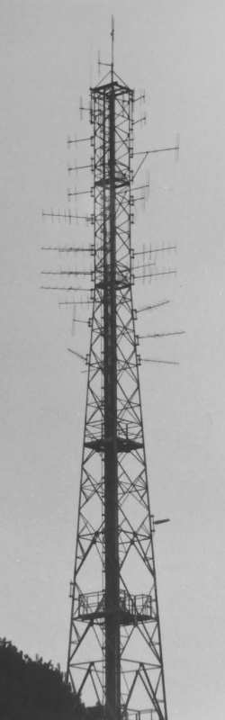
Typical HO Mast
The situation regarding radio masts at the end of the seventies was very different from today. There were very few lattice towers to be seen in the countryside, unlike now where mobile phone masts may be found every few kilometres. The cellular phone did not make its appearance until the late eighties, ten years after this episode in my life. Those few lattice towers that did exist were usually marked on maps as significant features. The purpose of the masts could be relatively easily determined by visual examination. Emergency Service / Civil Defence masts could be easily identified by their VHF 6 element Yagi aerials used to link the hilltop sites to the police or fire controls. No other services were permitted to use VHF radio links.
With the help of the local library I had gained quite a bit of information about how the police and fire radio schemes worked. The Home Office Directorate of Telecommunications published quite a lot of detail including the frequency bands they used. The band from 97 to 103 Megahertz was used for the Emergency Services, much to the consternation of our European neighbours, who used it for broadcasting. The general public could listen into the police and fire transmissions using their Stereo's (VHF FM radios) but reception of the AM signals were poor. Only the control room side of the conversation could be heard, so the juicier bits, the mobile side of the conversation was replaced by a pip tone. Weaker distant signals from other counties would be blotted out by strong local signals.
In the early seventies reasonably cheap 'Wideband' radios, intended for the American market became available in ordinary shops. These covered the Air Band 108-138MHz and Public Service 144-174MHz as well as the usual FM broadcast 88-108MHz band. Scanning receivers were not available to the general public at that time. In the mid seventies, scanning receivers began to be offered for sale in specialist radio magazines. The scanner that I purchased would be £2,000 in today's money [2013].
The Emergency services vacated the broadcast band during the mid eighties and moved to another frequency band. By the time this happened scanning receivers had become available but their high price limited availability. When analogue mobile phones appeared in the early nineties, the sales of scanning receivers boomed, as people bought them to eavesdrop on peoples phone calls. The owners started to listen to emergency service transmissions too, to such an extent that nothing was now private.
During the mid-two thousands the Police moved to a totally secure radio system and the Fire and Ambulance authorities followed by the end of the decade. The Public Safety Radio Communications known as 'Airwave' in the UK, provides a communication network on European wide standard, digital encrypted, voice and data using a common set of frequencies. After more than 30 years, this totally put an end to eavesdroppers.
The Initial Discovery
A number of factors came together around 1979. Firstly a friend, who used a 'Wideband' radio to listen to the fire brigade link frequencies, reported his reception blocked by a very strong signal containing white noise. Using my amateur radio receiver to tune above the 2 metre band. The white noise turned out to be on 147.000 MHz, which was in the Home Office band. It did not take much effort to trace the signal to the nearby HO hilltop site at Old Gorse. (Not a secret - The local newspaper carried an article when a new mast was installed for the 'Police' at Old Poor's Gorse) This signal persisted for a few weeks then disappeared, I assume the fault was cleared. The final thing was changing jobs and as a result had to visit ROC sites. Details of their exercise were available which indicated when radio tests were being performed.
On the first occasion that I was aware a ROC exercise was taking place, I decided to try to find their frequencies. A hunch made me listen on the frequency where we had heard the white noise. Much to my surprise, there was Bedford talking to its monitoring posts. Further tuning between 147 and 147.3MHz revealed other frequencies in use. Unlike the on-off transmissions to the posts, these were continuously on. I had stumbled on some of the frequencies used for the inter-group links. None were coming from Old Gorse, but from the north and south of my location. At this time, I was only able to listen between 146 and 148MHz with my amateur receiver, designed for the American market. It required the purchase of my scanning receiver for things to progress further.
Hunting down the Masts
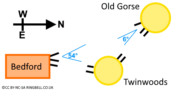
The next thing was to pay Old Gorse a visit to see what was going on there. High up the mast were yagi aerials pointing in the expected directions for the police and fire services. However lower down the mast were two VHF yagi aerials pointing north-westerly (Skeffington) and three pointing south-easterly, I was convinced these five yagis had to be for the ROC. Only later it was found these south easterly aerials didn't all point to the same location, but with only 6° separation, it wasn't possible to tell from a distance.
Next came a visit to Bedford ROC HQ, in Bromham Road, Biddenham. This had a wind up tower, currently in the down position as no exercise was in progress, containing loads of VHF 3 element yagi aerials. Two pointing north-east, four pointing south and three east-southeast. Additionally a 6 element yagi pointed north-westerly in the direction of Old Gorse. However there were three aerials at Old Gorse but only one here at the ROC.
The Relationship between Bedford - Twinwoods - Old Gorse
On the way home, I spotted a Home Office mast at Twinwoods Farm, Oakley, just north of Bedford. On diverting to pay it a visit there were the expected Police yagis high up pointing into Bedford. Again lower down the mast, two 3 element yagis pointed toward ROC Bedford matching those pointing here. There were two 6 element yagis pointing north-westerly towards Old Gorse. Completing the match. This opened up the question, why two radio links came via Twinwoods to Old Gorse, but one went there directly. The answer came later once the link frequencies were discovered.
It seems so sad to say it now, but I planned my 1979-80-81 holidays so I could visit as many ROC locations in the East of England as possible and trace out the links by looking out for masts on the way. As I said previously, many were marked on the map, so this was not too difficult.
Hunting the Frequencies
Things moved on when I purchased a scanning receiver. Every Friday morning the ROC tested their communications links. The radio test was done about 10am. So it was a case of being near a mast at the right time. I was able to have a Friday off from work every fortnight, which facilitated the search. Luckily each link was tested separately which enabled both the strong local transmitter to be heard and the link back from the next mast. Travelling time meant only the links in the vicinity of my home had their frequencies measured.
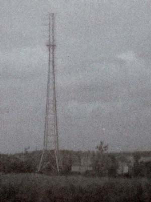
Old Poor's Gorse [1980]
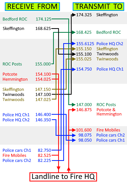
The frequencies were arranged in two pairs of blocks. A duplex link requires speech to be transmitted simultaneously in both directions necessitating two transmitter chains. A link between hilltop sites would normally use matching channels in each direction. For example, on the Coventry - Bedford circuit, its link between Old Gorse and Skeffington used 147.150 MHz for speech in the Coventry to Bedford direction, and 155.150 MHz for speech in the Bedford to Coventry direction. Frequencies in this band were separated by 8 MHz, those in the 168 / 174 bands had a 5.5 MHz separation.
Measuring the frequencies used at various masts answered the puzzle about why two of the three northbound aerials at Bedford Group HQ pointed at Twinwoods, those were the two inter-group links. Whilst the third aerial at Bedford pointed directly at Old Gorse, as it was added some years later, for the link to the repeater on the Group to Post Radio scheme
I was able to determine all the VHF frequencies used at Old Gorse, my closest mast. These are shown on the diagram above and include two Northamptonshire Police M2NG channels (BLUE), Northamptonshire Fire M2NO (RED), UKWMO Group HQ link between Bedford and Lincoln (BLACK), UKWMO group HQ link between Bedford and Coventry and Bedford ROC Post scheme (TEAL).
Its an awful example of frequency planning as there are transmitters and receivers operating in the same band. There was no conflict between the Police and UKWMO links, which were added first. The problem started when ROC Post radio was added some years later, causing conflict in all four link bands. In the late seventies, the fire brigade separated from the police radio scheme and their own scheme was added, causing further conflict in the 146 and 154 bands.
Finding the Regional Government Headquarters (RGHQ) or not
Bawburgh Polaroid [7-May-1981]
My friend Chris visited Norfolk fire brigade headquarters in Hethersett and remarked he could see a Home Office style mast about two miles away, but none of the aerials on the fire control pointed in that direction. I planned my 1981 holiday to take in Norwich and Lincoln, as they were both ROC Group HQ locations. I investigated the mast Chris had identified and wandered into the woods beside the mast and spotted a bungalow with blacked out windows and various air vents nearby. I had read in the daily papers about Regional Government bunkers disguised as bungalows. Putting two and two together I realised I had struck gold and found a RGHQ near the village of Bawburgh on the outskirts of Norwich. Using a 2" square Polaroid to take two pictures of the communications mast, neither turned out to be very good, but on this enlargement, the aerials are just visible. Click the Polaroid image to see a photo taken with a decent camera and slide film.
The mast contained seven VHF yagi aerials that appeared to be ROC links. There were thirteen UHF yagis, my scanner revealed seven UHF carriers emanating from the site. One of these on 466.025 MHz formed a pair with 452.025 MHz being transmitted at the Norwich ROC group HQ. The UKWMO booklet showed a link from Group HQs to RGHQs, so this confirmed I had indeed found gold. Up until now I had not paid any attention to the UHF yagi aerials although I had seen them at all group headquarters. There were numerous UHF yagis on Home Office hilltop sites pointing in all sorts of directions but I had no explanation of their purpose until now. A strong signal on 452.125 MHz in the vicinity of Norwich City Hall had a matching link at the Bawburgh end on 466.125 MHz, although they did not appear in the UKWMO booklet, Council emergency headquarters also have radio links to their RGHQ.
Later in the holiday at a hilltop site near Fulletby in Lincolnshire, I started paying attention to the UHF yagis, which pointed in various directions, but strangely four were pointing eastwards, not in the direction of any habitation centres. Eighteen years later, when I first stumbled on the SUBBRIT web site, I discovered that a RGHQ was located 9 miles away at Skendleby which fell almost directly on the line I had drawn on my map in 1981. If only I had driven down the line on that day. On the same holiday I visited masts at Caistor, Kirkby Underwood and Carlton Scroop before returning home.
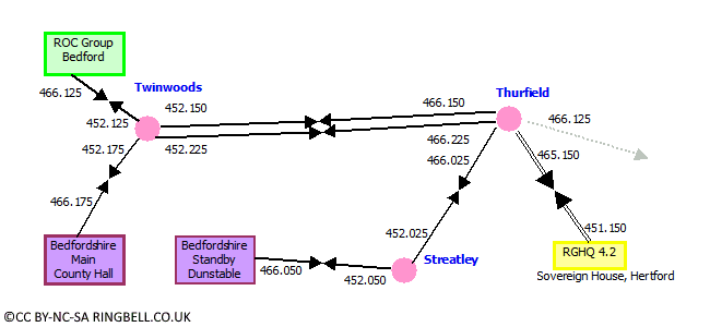
On a Friday off work, I visited Bedford ROC to measure the links during the test and then drove to the Reed hilltop mast (named Thurfield by the H.O.), there were twelve UHF yagis, a carrier on 451.150 matched a 465.150 signal I traced to Sovereign House, Hertford. However being totally unaware of the locations of the RGHQs I had just assumed this was like the other UHF links from a typical County Council. At Bedford, the Council HQ (466.175) and Bedford ROC (466.125) had links connected to Twinwoods (452.125 & 452.175) then relayed out (452.150 & 452.225) towards Reed (466.150 & 466.225). There were two other links at Reed, 466.025 went on to the Streatley mast where it was relayed on to an unknown destination, possibly the 'Bedfordshire Standby' council bunker wherever that was. One remaining frequency at Reed, 466.125 was never traced. There were many more UHF aerials pointing in different directions than can accounted for by the measured frequencies.
Links to RGHQ 4.2 [1981]
Mistakenly I had assumed all these links around Bedfordshire and Hertfordshire eventually led back to Bawburgh and not that Sovereign House was itself a RGHQ. So in hindsight, this was the second RGHQ to slip through my fingers in a matter of months. In early September 1981, I heard that I had passed my promotion board and would be given a job in Birmingham. The summer of discovery came to an end when I moved home in the autumn. This stopped any further investigations otherwise more might have been revealed. In July 1982 after my house move, I went to the company's training school in Staffordshire and noted a number of very strong UHF signals, but didn't pursue them, which is a pity as they were coming from RGHQ 9.1 only a mile away at Swynnerton. A third RGHQ had slipped through my grasp. All would be revealed in eighteen years time, but sadly that was eight years after stand down.
Conclusion
Due to the ease in which Home Office hilltop sites could be recognised and that the ROC links were always lower down the structure than the police and fire links, the job of tracing parts of the ROC network was made easier. It is interesting to note the ROC was the poor relation to the other services, it used one aerial for both transmit and receive whereas the police and fire had two separate aerials.
On the map I drew in 1982, some frequencies were not found but the lines are still included. I'm just so sorry I didn't put more effort in to finding the links way back then. Hindsight is a great thing. Information I received in 2010 showed a couple of my guesses of aerial directions at Coventry ROC Group in 1979 were a little off course. In April 2013, photographs of the Bawburgh mast taken in the seventies were released by SubBrit, it is now clear that some of the aerial headings I had recorded were wrong, the map in the next topic has all these errors corrected.
As a total outsider I was pleased with what I had discovered, I am sure people who worked for the Home Office Directorate of Telecommunications (DTELs) would laugh at my pathetic attempts. I would love to know if the whole UKWMO network was documented. Perhaps before my death the archives may be released to reveal the true path of these links and confirm if the frequencies were indeed correct. Duncan Campbell's War Plan UK would have been a great help in locating the RGHQs, but I was unaware of its publication. In the mid-eighties the network described here was replaced by a microwave spine with UHF branches and many of the old radio frequencies reused for emergency services.
Filling in the gaps : Thanks to Feedback to the website
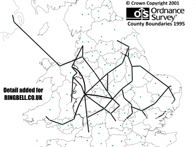
The diagram below, when enlarged with the zoom, shows details of the links, their frequencies and mast locations in Central England and North Wales. Hopefully now that 30 years has passed, the 'Official Secrets Act' closure period has ended, more information on the UKWMO radio scheme of the seventies will come to light.
UKWMO Links, Midlands and Wales
As result of reading this page in 2004, Martin sent me a copy of a drawing he found blowing around a car park near a Home Office hilltop site that was being cleared 10 years earlier. This was a hand drawn sketch of a diagram CB429 showing the UKWMO VHF radio links. The sketch is of particular interest as it dates from 1978, the same era as my research. The drawing only shows the links passing through North Wales or on routes from Wrexham Group Headquarters.
Mike Hawkins has kindly provided copies of a former DTEL engineer's notes showing the links from Shrewbury and Coventry groups. I have redrawn all the original diagrams <link> to improve readability and added the OS Grid references of the sites. Where data is still missing, the routes are shown as grey squiggly lines.
If you have any personal notes relating to the VHF Home Defence links, enabling more paths to be plotted then please get in touch via my homepage link in the website menu.
The radio link from Belfast to Preston involved a 118 mile long path across the Irish Sea between Slieve Croob ( IJ316454 ) and Cefn Du ( SH835733 ). Further enquiries have revealed it operated using standard VHF link equipment and a 70 Watt amplifier feeding an 8 over 8 Yagi array. The radio backup to the landline circuit from Belfast to Carlisle had a much shorter link to the mainland (where?) from Cairngaver ( IJ454765 ). The Belfast Ayr landline link did not have a radio backup.
The network shown was switched off during the mid-eighties when many of the link frequencies were allocated for Police VHF communications as part of the WARC project. It was replaced with a new 'Highway System' using multiplexed links on frequencies in the 1500MHz band, known as RN1, this along with RN2 is described in detail Chapter : Second Generation Speech and Telegraph Network in the UKWMO and RGHQ Communications Networks section of the Chapter Index.
 This page is Copyright © RINGBELL.CO.UK, under a